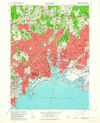
1960 Map of Bridgeport
USGS Topo · Published 1963About this map
Bridgeport Harbor and its industrial shoreline define this coastal landscape at the start of the 1960s. The dense urban core of East Bridgeport and Stratford is bisected by the New York New Haven and Hartford railroad and the modern Connecticut Turnpike, showing a city in its mid-century industrial peak. Extensive coastal features like the Great Meadows and Pleasure Beach contrast with the tightly packed residential blocks and numerous parochial institutions, including St Michaels School and St Marys School. To the north, the terrain rises into the residential neighborhoods of Toilsome Hill and Ox Hill, where large green spaces like Fairchild Wheeler Park and Fairchild Memorial Park break the grid. Along the waterfront, the University of Bridgeport and Seaside Park occupy a prominent position overlooking Long Island Sound, while the eastern edge is dominated by the Bridgeport Municipal Airport and the tidal waters of Johnsons Creek.
Find a feature on this map
120 named features on this map. Tap any name to fly to it.
Don’t see what you’re looking for? This feature index may not catch every label — zoom into the map to look around manually.
Map Details
Editions of this 1960 Bridgeport Map
This is the sole edition of this map. No revisions or reprints were ever made.
Other maps of this area

1889 · Derby
USGS Topo · 1:62,500

1891 · Bridgeport
USGS Topo · 1:62,500

1891 · Derby
USGS Topo · 1:62,500

1892 · Danbury
USGS Topo · 1:62,500

1892 · Norwalk
USGS Topo · 1:62,500

1893 · Bridgeport
USGS Topo · 1:62,500

1893 · Norwalk
USGS Topo · 1:62,500

1893 · Derby
USGS Topo · 1:62,500

1915 · Danbury
USGS Topo · 1:62,500

1920 · Bridgeport
USGS Topo · 1:62,500