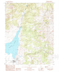
1989 Map of Bridgeport
USGS Topo · Published 1989About this map
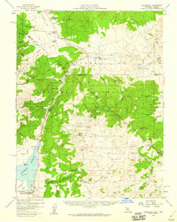
The town of Bridgeport sits at the edge of the Bridgeport Reservoir, serving as a central hub in this high-altitude landscape during the late twentieth century. To the east, the mining legacy of the region is evident near Masonic Mountain, where the Chemyung Mine and the settlement of Masonic are located. Numerous prospects and the Success Mine dot the terrain, illustrating the historical search for minerals across the Bodie Hills and the slopes of the Sweetwater Mountains.
Find a feature on this map
32 named features on this map. Tap any name to fly to it.
Don’t see what you’re looking for? This feature index may not catch every label — zoom into the map to look around manually.
Map Details
Editions of this 1989 Bridgeport Map
This is the sole edition of this map. No revisions or reprints were ever made.
Other maps of this area

1909 · Bridgeport
USGS Topo · 1:125,000

1911 · Bridgeport
USGS Topo · 1:125,000

1920 · Bridgeport
USGS Topo · 1:125,000

1948 · Walker Lake
USGS Topo · 1:250,000
1956 · Fales Hot Springs
USGS Topo · 1:62,500
1956 · Matterhorn Peak
USGS Topo · 1:62,500

1957 · Walker Lake
USGS Topo · 1:250,000
1958 · Bodie
USGS Topo · 1:62,500
1958 · Bridgeport
USGS Topo · 1:62,500

1962 · Walker Lake
USGS Topo · 1:250,000