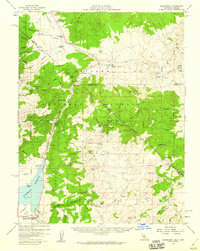
1958 Map of Bridgeport
USGS Topo · Published 1960About this map
Bridgeport serves as the primary hub in the high country of the Toiyabe National Forest, sitting at the edge of the Bridgeport Valley and the Walker River Reservoir. This 1958 field-checked survey reveals an era of transition for the region, where once-active mining camps and stage stops have been reduced to legacy sites. To the east, the Masonic district remains a focal point of historical interest, with numerous named claims such as the Pittsburg Liberty Mine, Serita Mine, and Chemung Mine situated around the slopes of Masonic Mountain. The map traces a network of high-elevation ranching and transportation, from the Conway Stage Sta along the Stage Road to established outposts like Sweetwater Ranch and Fredericks Ranch. Significant infrastructure of the mid-20th century is evident, including Bryant Field airport and the Gaging Station monitoring the East Walker River.
Find a feature on this map
94 named features on this map. Tap any name to fly to it.
Don’t see what you’re looking for? This feature index may not catch every label — zoom into the map to look around manually.
Map Details
Editions of this 1958 Bridgeport Map
4 editions found
Other maps of this area

1891 · Wellington
USGS Topo · 1:125,000

1893 · Wellington
USGS Topo · 1:125,000

1909 · Hawthorne
USGS Topo · 1:250,000

1909 · Bridgeport
USGS Topo · 1:125,000

1911 · Bridgeport
USGS Topo · 1:125,000

1911 · Hawthorne
USGS Topo · 1:250,000

1915 · Hawthorne
USGS Topo · 1:250,000

1920 · Bridgeport
USGS Topo · 1:125,000

1948 · Walker Lake
USGS Topo · 1:250,000

1956 · Mt. Grant
USGS Topo · 1:62,500