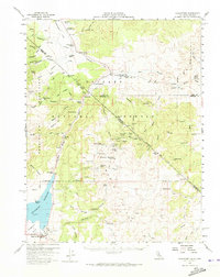
1958 Map of Bridgeport
USGS Topo · Published 1973About this map
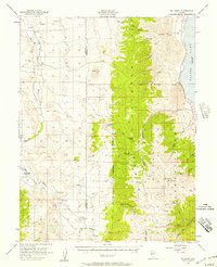
Bridgeport serves as the focal point of this late 1950s survey, situated at the edge of the Bridgeport Reservoir near the Bryant Airport. The map captures a high-altitude borderland where California meets Nevada, marked by the historical Von Schmidt Line. High-desert mining activity is a defining characteristic of the landscape, particularly around Masonic Mountain, where the Masonic townsite and operations like the Pittsburg Liberty Mine, Serita Mine, and Chemung Mine are documented. Ranching and early transportation infrastructure are evident through named holdings such as Sweetwater Ranch and the Conway Stage Sta along the Stage Road. The presence of several former settlements, including Star City and Monte Cristo, provides a valuable look at the shifting population centers of the Sweetwater Mountains during this era.
Find a feature on this map
82 named features on this map. Tap any name to fly to it.
Don’t see what you’re looking for? This feature index may not catch every label — zoom into the map to look around manually.
Map Details
Editions of this 1958 Bridgeport Map
4 editions found
Other maps of this area

1891 · Wellington
USGS Topo · 1:125,000

1893 · Wellington
USGS Topo · 1:125,000

1909 · Hawthorne
USGS Topo · 1:250,000

1909 · Bridgeport
USGS Topo · 1:125,000

1911 · Bridgeport
USGS Topo · 1:125,000

1911 · Hawthorne
USGS Topo · 1:250,000

1915 · Hawthorne
USGS Topo · 1:250,000

1920 · Bridgeport
USGS Topo · 1:125,000

1948 · Walker Lake
USGS Topo · 1:250,000
1956 · Mt. Grant
USGS Topo · 1:62,500