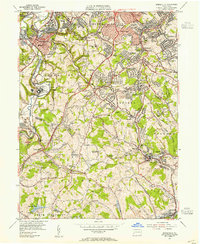
1953 Map of Bridgeville
USGS Topo · Published 1955About this map
Chartiers Creek and the Pittsburgh and West Virginia Railway define the industrial and transit corridor of this mid-century landscape. The map captures a period of intense suburban transition in the South Hills, where residential developments like Beverly Heights and Ruthfred Acres sit adjacent to active and legacy resource extraction sites. Evidence of the region's energy history is everywhere, from the Bower Hill Oil Well and various Gas Wells to the extensive Mine Dump and Strip Mine operations.
Find a feature on this map
110 named features on this map. Tap any name to fly to it.
Don’t see what you’re looking for? This feature index may not catch every label — zoom into the map to look around manually.
Map Details
Editions of this 1953 Bridgeville Map
This is the sole edition of this map. No revisions or reprints were ever made.
Other maps of this area

1901 · Amity
USGS Topo · 1:62,500

1902 · Brownsville
USGS Topo · 1:62,500

1904 · Amity
USGS Topo · 1:62,500

1904 · Mc Keesport
USGS Topo · 1:62,500

1904 · Carnegie
USGS Topo · 1:62,500

1906 · Brownsville
USGS Topo · 1:62,500

1906 · Carnegie
USGS Topo · 1:62,500

1907 · Pittsburg
USGS Topo · 1:62,500

1908 · Carnegie
USGS Topo · 1:62,500

1931 · Brownsville
USGS Topo · 1:62,500