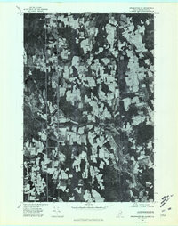
1975 Map of Bridgewater SE
USGS Topo · Published 1981About this map
Monticello serves as the central hub of this agricultural and timber landscape along the international border in the mid-1970s. The mosaic of cleared fields and dense woodlots is bisected by the North Branch Meduxnekeag River, which meanders eastward toward the United States Canada boundary. Small rural clusters and family-named landmarks like Jewells Corner, Sharp, and Hill anchor the crossroads of this borderland, reflecting the persistent settlement patterns of northern Maine. The map's orthophoto base reveals the intricate texture of the terrain, from the riparian corridor of Dead Stream to the expansive potato fields near Bloomfield. This aerial perspective documents the land-use patterns of Aroostook County before modern consolidation, providing a clear record of the roads and farmsteads that defined the region during this era.
Find a feature on this map
9 named features on this map. Tap any name to fly to it.
Don’t see what you’re looking for? This feature index may not catch every label — zoom into the map to look around manually.
Map Details
Editions of this 1975 Bridgewater SE Map
This is the sole edition of this map. No revisions or reprints were ever made.
Other maps of this area

1934 · Bridgewater
USGS Topo · 1:48,000

1938 · Bridgewater
USGS Topo · 1:62,500

1938 · Houlton
USGS Topo · 1:62,500

1951 · Houlton
USGS Topo · 1:62,500

1951 · Bridgewater
USGS Topo · 1:62,500

1953 · Bridgewater
USGS Topo · 1:50,000

1959 · Woodstock
USGS Topo · 1:250,000

1963 · Woodstock
USGS Topo · 1:250,000
1975 · Houlton NW
USGS Topo · 1:24,000
1975 · Houlton NE
USGS Topo · 1:24,000