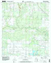
1998 Map of Brimstone
USGS Topo · Published 2000About this map
The Edgerly Oil Field and Sulphur Oil Field anchor this industrial landscape of southwestern Louisiana, reflecting the region's deep ties to mineral extraction. In this territory north of the Gulf, the terrain is defined by the winding course of the Houston River and the engineered precision of the Houston River Canal. Industrial infrastructure is prominent, with numerous pipelines crisscrossing the marshy lowlands near Brimstone. The map also captures specialized transport features like a Landing Strip and a Landing Field, alongside water bodies such as Richards Lake and Edwards Gully. For those tracing local history, the De Quincy Lookout Tower stands as a notable landmark overlooking the intersection of natural waterways and 20th-century energy development.
Find a feature on this map
14 named features on this map. Tap any name to fly to it.
Don’t see what you’re looking for? This feature index may not catch every label — zoom into the map to look around manually.
Map Details
Editions of this 1998 Brimstone Map
This is the sole edition of this map. No revisions or reprints were ever made.
Other maps of this area

1932 · Orange
USGS Topo · 1:62,500

1935 · Buhler
USGS Topo · 1:31,680

1935 · Gordon
USGS Topo · 1:31,680

1947 · Sulphur
USGS Topo · 1:31,680

1947 · Vinton
USGS Topo · 1:31,680

1947 · DeQuincy
USGS Topo · 1:31,680

1947 · Sulphur Mines
USGS Topo · 1:31,680
1947 · West Lake
USGS Topo · 1:31,680

1947 · Lunita
USGS Topo · 1:31,680

1947 · Long Marsh
USGS Topo · 1:31,680