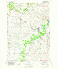
1973 Map of Broadus
USGS Topo · Published 1976About this map
Broadus stands as the primary hub of activity in this 1970s survey, situated along the winding banks of the Powder River. The town's layout reflects a classic rural Montana community, featuring the local High Sch and the Valley View Cem on the northern edge. Significant investment in aviation and community infrastructure is evident through the presence of the Airport, an Airway Beacon, and a dedicated Rodeo Ground near the town center.
Find a feature on this map
54 named features on this map. Tap any name to fly to it.
Don’t see what you’re looking for? This feature index may not catch every label — zoom into the map to look around manually.
Map Details
Editions of this 1973 Broadus Map
This is the sole edition of this map. No revisions or reprints were ever made.
Other maps of this area

1954 · Ekalaka
USGS Topo · 1:250,000

1956 · Ekalaka
USGS Topo · 1:250,000

1958 · Ekalaka
USGS Topo · 1:250,000

1965 · Ekalaka
USGS Topo · 1:250,000

1973 · Olive
USGS Topo · 1:24,000

1973 · Lonesome Peak
USGS Topo · 1:24,000

1973 · Monday Creek
USGS Topo · 1:24,000

1973 · Moonlight Creek
USGS Topo · 1:24,000

1973 · Hawkey Creek
USGS Topo · 1:24,000
1973 · Fighting Butte
USGS Topo · 1:24,000