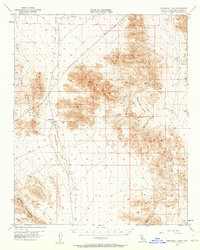
1955 Map of Broadwell Lake
USGS Topo · Published 1961About this map
The Broadwell (Site) marks a former settlement along an Old Railroad Grade in this arid region of the Mojave. This 1950s survey documents a landscape defined by ephemeral water and heavy mining exploration, where Broadwell Lake and Dry Lake dominate the basins between the Cady Mountains and the Bristol Mountains. Evidence of early 20th-century industry is found in scattered prospects and a shaft, while the presence of a abandoned well and a tank highlights the critical importance of water management in this desert environment. Travel through the area is restricted to a Jeep Trail, leading past geological curiosities like the Natural Arch and the secluded Hyten Spring on the eastern edge of Broadwell Mesa.
Find a feature on this map
14 named features on this map. Tap any name to fly to it.
Don’t see what you’re looking for? This feature index may not catch every label — zoom into the map to look around manually.
Map Details
Editions of this 1955 Broadwell Lake Map
3 editions found

Other maps of this area

1910 · Ivanpah
USGS Topo · 1:250,000

1912 · Ivanpah
USGS Topo · 1:250,000

1933 · Avawatz Mountains
USGS Topo · 1:250,000

1942 · Ivanpah
USGS Topo · 1:250,000

1942 · Amboy
USGS Topo · 1:250,000

1943 · Amboy
USGS Topo · 1:250,000

1947 · Trona
USGS Topo · 1:250,000

1947 · Kingman
USGS Topo · 1:250,000

1948 · Kingman
USGS Topo · 1:250,000

1948 · Trona
USGS Topo · 1:250,000