2023 Map of Brocton
USGS Topo · Published 2023About this map
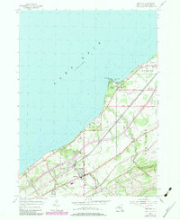
The Lake Erie shoreline of Chautauqua County defines this 2023 survey, capturing the transition from the waterfront communities of Van Buren Point and Greencrest to the inland agricultural and residential clusters. The terrain is deeply etched by waterways such as Little Canadaway Creek, Slippery Rock Creek, and Walker Creek, which flow northwest toward Van Buren Bay. These natural drainages dictated the early layout of regional roads and the placement of historic settlements like Brocton and Portland.
Find a feature on this map
64 named features on this map. Tap any name to fly to it.
Don’t see what you’re looking for? This feature index may not catch every label — zoom into the map to look around manually.
Map Details
Editions of this 2023 Brocton Map
This is the sole edition of this map. No revisions or reprints were ever made.