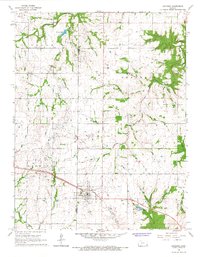
1966 Map of Bronson
USGS Topo · Published 1967About this map
Bronson stands as the primary hub of this 1960s Kansas landscape, situated along the Missouri Pacific rail line at the border of Allen and Bourbon counties. The town is surrounded by a rural terrain defined by townships such as Osage, Franklin, and Marion, where the agricultural economy is punctuated by local extractive industries like an Oil Field and various Oil Wells. The map reveals a sophisticated water management network, featuring the Little Osage River in the north and the Marmaton River in the south, alongside smaller bodies like Dawson Lake and the Bronson Reservoir. Genealogists will find significant value in the distribution of family-named resting places, including the South Osage, Ensminger, and Pleasant Ridge cemeteries. A unique historical layer is preserved in the Old Schubert Creek Grade Railroad, indicating a shift in the region's transportation infrastructure.
Find a feature on this map
23 named features on this map. Tap any name to fly to it.
Don’t see what you’re looking for? This feature index may not catch every label — zoom into the map to look around manually.
Map Details
Editions of this 1966 Bronson Map
This is the sole edition of this map. No revisions or reprints were ever made.
Other maps of this area

1884 · Fort Scott
USGS Topo · 1:125,000

1885 · Garnett
USGS Topo · 1:125,000

1886 · Iola
USGS Topo · 1:125,000

1886 · Fort Scott
USGS Topo · 1:125,000

1887 · Mound City
USGS Topo · 1:125,000

1893 · Fort Scott
USGS Topo · 1:125,000

1893 · Iola
USGS Topo · 1:125,000

1893 · Mound City
USGS Topo · 1:125,000

1894 · Garnett
USGS Topo · 1:125,000

1904 · Iola
USGS Topo · 1:125,000