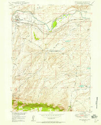
1949 Map of Brookhurst
USGS Topo · Published 1958About this map
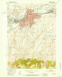
The North Platte River carves through this Natrona County landscape, serving as a primary corridor for both natural drainage and industrial transport. Along its southern banks, the Chicago and Northwestern and Burlington and Quincy railroads parallel the water, supporting mid-century operations at Pratt Spur and the nearby Gravel Pit. The map reveals an era of energy development with multiple Pipe Line labels and significant Oil Tanks clustered near Brookhurst.
Find a feature on this map
33 named features on this map. Tap any name to fly to it.
Don’t see what you’re looking for? This feature index may not catch every label — zoom into the map to look around manually.
Map Details
Editions of this 1949 Brookhurst Map
This is the sole edition of this map. No revisions or reprints were ever made.
Other maps of this area
1949 · Campbell Hill
USGS Topo · 1:24,000
1949 · Pratts Soda Lakes
USGS Topo · 1:24,000

1950 · Campbell Hill
USGS Topo · 1:24,000

1950 · Lockett
USGS Topo · 1:24,000
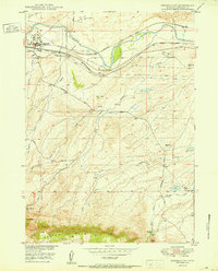
1950 · Brookhurst
USGS Topo · 1:24,000

1950 · Pratts Soda Lakes
USGS Topo · 1:24,000

1951 · The Reefs
USGS Topo · 1:24,000
1951 · Casper
USGS Topo · 1:24,000

1955 · Casper
USGS Topo · 1:250,000

1958 · Casper
USGS Topo · 1:250,000