
1949 Map of Campbell Hill
USGS Topo · Published 1958About this map
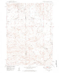
The Cole Creek Oil Field dominates the northern landscape of this map, reflecting the mid-century energy development that shaped the border of Natrona and Converse counties. Numerous Oil Wells, a Pumping Sta, and Oil Tanks suggest a bustling industrial pocket set against an otherwise sparsely populated grazing landscape. The terrain is marked by family-run livestock operations like the Hyland Sheep Ranch, Double Bar Two Ranch, and Three Bar C Ranch, which utilized the scattered Windmills for water in an arid environment.
Find a feature on this map
21 named features on this map. Tap any name to fly to it.
Don’t see what you’re looking for? This feature index may not catch every label — zoom into the map to look around manually.
Map Details
Editions of this 1949 Campbell Hill Map
3 editions found
Other maps of this area

1949 · Brookhurst
USGS Topo · 1:24,000

1949 · Parkerton
USGS Topo · 1:24,000

1949 · Glenrock NW
USGS Topo · 1:24,000

1949 · Pratts Soda Lakes
USGS Topo · 1:24,000

1950 · Campbell Hill
USGS Topo · 1:24,000

1950 · Lockett
USGS Topo · 1:24,000

1950 · Brookhurst
USGS Topo · 1:24,000

1950 · Parkerton
USGS Topo · 1:24,000

1950 · Glenrock NW
USGS Topo · 1:24,000

1950 · Pratts Soda Lakes
USGS Topo · 1:24,000