
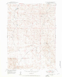
1950 Map of Glenrock NW
USGS Topo · Published 1950About this map
South Cole Creek Unit (Oil Field) defines the industrial character of this high plains landscape at mid-century. Produced as part of the Department of the Interior program for the development of the Missouri River Basin, the map illustrates an era of energy extraction in Converse County, marked by numerous Windmills and scattered Oil Wells. Significant infrastructure includes the CAA Building and several specialized transit routes like the Badger Coal Mine Road and the Glenrock-Ross Road. Settlement patterns are sparse, represented by isolated landmarks such as Spence and Hyland Ranch. The drainage of Lone Tree Gulch cuts through the terrain, while the geodetic marker at VABM Brown provides a fixed point in the shifting economy of coal, oil, and ranching that sustained the region during this post-war period.
Find a feature on this map
15 named features on this map. Tap any name to fly to it.
Don’t see what you’re looking for? This feature index may not catch every label — zoom into the map to look around manually.
Map Details
Editions of this 1950 Glenrock NW Map
This is the sole edition of this map. No revisions or reprints were ever made.
Other maps of this area

1949 · Campbell Hill
USGS Topo · 1:24,000

1949 · Parkerton
USGS Topo · 1:24,000

1949 · Glenrock
USGS Topo · 1:24,000

1949 · Glenrock NW
USGS Topo · 1:24,000

1949 · Hylton Ranch
USGS Topo · 1:24,000

1950 · Campbell Hill
USGS Topo · 1:24,000

1950 · Lockett
USGS Topo · 1:24,000

1950 · Parkerton
USGS Topo · 1:24,000

1950 · Glenrock
USGS Topo · 1:24,000
1950 · Hylton Ranch
USGS Topo · 1:24,000