
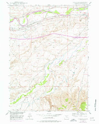
1949 Map of Parkerton
USGS Topo · Published 1966About this map
The Big Muddy Oil Field dominates this late-1940s landscape, illustrating the industrial character of Converse County during the post-war energy boom. The infrastructure of petroleum extraction is evident across the sheet, from the prominent Oil Refinery near Glenrock to the network of pipelines and service roads that crisscross the terrain. The North Platte River serves as a primary geographic anchor, its banks paralleled by two major rail lines: the Chicago and Northwestern and the Chicago Burlington and Quincy.
Find a feature on this map
21 named features on this map. Tap any name to fly to it.
Don’t see what you’re looking for? This feature index may not catch every label — zoom into the map to look around manually.
Map Details
Editions of this 1949 Parkerton Map
2 editions found
Other maps of this area

1949 · Campbell Hill
USGS Topo · 1:24,000

1949 · Glenrock
USGS Topo · 1:24,000

1949 · Glenrock NW
USGS Topo · 1:24,000

1949 · Hylton Ranch
USGS Topo · 1:24,000

1950 · Campbell Hill
USGS Topo · 1:24,000

1950 · Lockett
USGS Topo · 1:24,000

1950 · Parkerton
USGS Topo · 1:24,000

1950 · Glenrock NW
USGS Topo · 1:24,000

1950 · Glenrock
USGS Topo · 1:24,000
1950 · Hylton Ranch
USGS Topo · 1:24,000