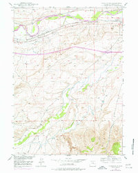
1949 Map of Parkerton
USGS Topo · Published 1977About this map
The Big Muddy Oil Field dominates this 1949 landscape, where an extensive network of pipelines and storage tanks traces the mid-century energy production of Converse County. Parallel rail lines, the Burlington Northern and the Chicago and Northwestern, follow the southern bank of the North Platte River, connecting the settlement of Parkerton to the expanding community at Glenrock.
Find a feature on this map
20 named features on this map. Tap any name to fly to it.
Don’t see what you’re looking for? This feature index may not catch every label — zoom into the map to look around manually.
Map Details
Editions of this 1949 Parkerton Map
2 editions found
Other maps of this area

1949 · Campbell Hill
USGS Topo · 1:24,000

1949 · Parkerton
USGS Topo · 1:24,000

1949 · Glenrock
USGS Topo · 1:24,000

1949 · Glenrock NW
USGS Topo · 1:24,000

1949 · Hylton Ranch
USGS Topo · 1:24,000

1950 · Campbell Hill
USGS Topo · 1:24,000

1950 · Lockett
USGS Topo · 1:24,000

1950 · Parkerton
USGS Topo · 1:24,000

1950 · Glenrock NW
USGS Topo · 1:24,000

1950 · Glenrock
USGS Topo · 1:24,000