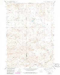
1949 Map of Campbell Hill
USGS Topo · Published 1985About this map
Cole Creek Oil Field and the surrounding high plains of the Natrona and Converse county line define this mid-century western landscape. The 1949 survey illustrates an economy transitioning between traditional livestock operations and extractive industries, visible through the proximity of the Big Muddy Coal Mine and scattered infrastructure like the Pumping Sta and various Oil Wells. The rugged terrain, centered around Campbell Hill and Johnson Hill, is partitioned by several established ranching estates, including the Hyland Sheep Ranch and the Three Bar Ranch. Drainage patterns like Cole Creek and Lone Tree Gulch dictate the placement of local thoroughfares such as Cole Creek Road, providing a clear look at how the topography shaped Wyoming's early energy and agricultural development.
Find a feature on this map
16 named features on this map. Tap any name to fly to it.
Don’t see what you’re looking for? This feature index may not catch every label — zoom into the map to look around manually.
Map Details
Editions of this 1949 Campbell Hill Map
3 editions found
Other maps of this area

1949 · Brookhurst
USGS Topo · 1:24,000

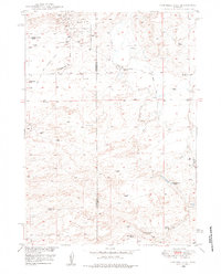
1949 · Campbell Hill
USGS Topo · 1:24,000

1949 · Parkerton
USGS Topo · 1:24,000

1949 · Glenrock NW
USGS Topo · 1:24,000

1949 · Pratts Soda Lakes
USGS Topo · 1:24,000

1950 · Campbell Hill
USGS Topo · 1:24,000

1950 · Lockett
USGS Topo · 1:24,000

1950 · Brookhurst
USGS Topo · 1:24,000

1950 · Parkerton
USGS Topo · 1:24,000

1950 · Glenrock NW
USGS Topo · 1:24,000