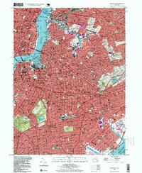
1995 Map of Brooklyn
USGS Topo · Published 1999About this map
Prospect Park serves as a massive green anchor for the dense residential grids of Park Slope and Flatbush in this late-twentieth-century study of the urban landscape. The map details a complex transit network of bridges and tunnels, including the Brooklyn Bridge and the Queens Midtown Tunnel, linking the boroughs across the East River. Major institutional footprints like New York University, the United Nations Headquarters, and Kings County Hospital are clearly delineated alongside industrial waterfronts at the Navy Yard Basin and Newtown Creek. Vast tracts are dedicated to the city's quietest residents, with the Cemetery of the Holy Cross and Calvary Cemetery forming significant open spaces within the tightly packed neighborhoods of East Flatbush and Sunnyside.
Find a feature on this map
87 named features on this map. Tap any name to fly to it.
Don’t see what you’re looking for? This feature index may not catch every label — zoom into the map to look around manually.
Map Details
Editions of this 1995 Brooklyn Map
This is the sole edition of this map. No revisions or reprints were ever made.
Other maps of this area

1888 · Paterson
USGS Topo · 1:62,500

1889 · Brooklyn
USGS Topo · 1:62,500

1891 · Brooklyn
USGS Topo · 1:62,500

1891 · Harlem
USGS Topo · 1:62,500

1892 · Paterson
USGS Topo · 1:62,500

1897 · Harlem
USGS Topo · 1:62,500

1897 · Brooklyn
USGS Topo · 1:62,500

1898 · Harlem
USGS Topo · 1:62,500

1898 · Staten Island
USGS Topo · 1:62,500

1898 · Brooklyn
USGS Topo · 1:62,500