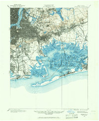
1897 Map of Brooklyn
USGS Topo · Published 1966About this map
Jamaica Bay and its labyrinth of salt marshes anchor this late-19th-century survey, revealing a landscape defined by water and the burgeoning expansion of Kings and Queens counties. Before the era of massive land reclamation, the bay is a complex network of hassocks and channels like Yellow Bar Hassock and Pumpkinpatch Channel. The map documents a critical period of transit development, where multiple rail lines including the Long Island R.R. and the New York & Sea Beach R.R. converge toward the coast, servicing early seaside resorts and expanding residential hubs.
Find a feature on this map
110 named features on this map. Tap any name to fly to it.
Don’t see what you’re looking for? This feature index may not catch every label — zoom into the map to look around manually.
Map Details
Editions of this 1897 Brooklyn Map
3 editions found
Other maps of this area

1888 · Paterson
USGS Topo · 1:62,500

1888 · Sandy Hook
USGS Topo · 1:62,500

1889 · Brooklyn
USGS Topo · 1:62,500

1891 · Brooklyn
USGS Topo · 1:62,500

1891 · Harlem
USGS Topo · 1:62,500

1892 · Paterson
USGS Topo · 1:62,500

1893 · Sandy Hook
USGS Topo · 1:62,500

1897 · Harlem
USGS Topo · 1:62,500

1897 · Brooklyn
USGS Topo · 1:62,500

1897 · Hempstead
USGS Topo · 1:62,500