
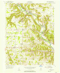
1956 Map of Brookville
USGS Topo · Published 1957About this map
Brookville sits at the significant confluence where the Whitewater River meets its East Fork, a geography that defined the town's early industrial and transport identity. This mid-1950s survey captures the region's transition, showing the New York Central railroad following the path of the earlier Whitewater Canal, with an Aqueduct and Covered Bridge still marking the landscape. The intricate drainage network of Wolf Creek, Duck Creek, and Pipe Creek carves through the terrain, separating upland settlements like Blooming Grove and Oak Forest. For local historians and genealogists, the map preserves the exact locations of several spiritual and community landmarks, including St Michaels Cem, Maple Grove Cemetery, and the Flood Victims Memorial, which stands as a reminder of the river's historical impact on the valley's residents.
Find a feature on this map
53 named features on this map. Tap any name to fly to it.
Don’t see what you’re looking for? This feature index may not catch every label — zoom into the map to look around manually.
Map Details
Editions of this 1956 Brookville Map
This is the sole edition of this map. No revisions or reprints were ever made.
Other maps of this area

1915 · College Corner
USGS Topo · 1:48,000

1915 · Harrison
USGS Topo · 1:48,000

1918 · College Corner
USGS Topo · 1:62,500

1946 · Batesville
USGS Topo · 1:24,000

1948 · Fairfield
USGS Topo · 1:24,000

1953 · Cincinnati
USGS Topo · 1:250,000

1955 · Mount Carmel
USGS Topo · 1:24,000
1955 · Cedar Grove
USGS Topo · 1:24,000

1956 · Everton
USGS Topo · 1:24,000

1956 · Alpine
USGS Topo · 1:24,000