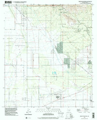
1996 Map of Brown Mountain
USGS Topo · Published 2002About this map
Tucson Mountains and the arid expanse of the Avra Valley define this landscape as it appeared in the late 1990s. The map captures a unique intersection of conservation and mid-century cultural history, featuring the Arizona-Sonora Desert Museum alongside the film-history site Old Tucson. To the west, the Tohono O'odham Indian Reservation boundary marks a distinct shift in land use, while aviation history is represented by Ryan Field near the southern edge. The map meticulously tracks water management in the desert, from the ancient-style Aqueduct and numerous flumes to modern Sewage Treatment Ponds. Isolated landmarks like Robles Well and San Joaquin Well serve as critical reference points in the open valley, while recreational areas like Gilbert Ray Campground indicate the area's transition into a regional park and wilderness destination.
Find a feature on this map
34 named features on this map. Tap any name to fly to it.
Don’t see what you’re looking for? This feature index may not catch every label — zoom into the map to look around manually.
Map Details
Editions of this 1996 Brown Mountain Map
This is the sole edition of this map. No revisions or reprints were ever made.
Other maps of this area

1925 · San Xavier
USGS Topo · 1:62,500

1934 · Tucson Mountains
USGS Topo · 1:125,000

1941 · Cocoraque Butte
USGS Topo · 1:62,500

1943 · Cocoraque Butte
USGS Topo · 1:62,500

1943 · San Xavier Mission
USGS Topo · 1:62,500

1947 · Cortaro
USGS Topo · 1:62,500

1956 · Tucson
USGS Topo · 1:250,000

1957 · San Xavier Mission
USGS Topo · 1:62,500

1957 · Cortaro
USGS Topo · 1:62,500

1958 · Tucson
USGS Topo · 1:250,000