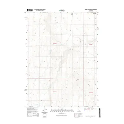
2015 Map of Browns Bench Ranch
USGS Topo · Published 2015About this map
Browns Bench Ranch sits at the high northern edge of this high-desert plateau, where the border between Idaho and Nevada is marked by the shifting topography of the Salmon River Range. This 2015 survey reveals a landscape shaped by water and elevation, dominated by the long escarpment of Browns Bench. Water sources are critical here, evidenced by Upper Maggie Spring and Burnt Creek Spring, which feed into the drainages of Cottonwood Cr. The map details a network of access points through Oneil RD and various BLM RD routes, tracing the transition from the cattle-ranching operations at the ranch to the more open grazing land at Cottonwood Field. Toward the southern end of the quadrangle, the terrain rises toward the summit of Grassy Mtn, providing a clear view of the complex land management boundaries in this tri-state corner.
Find a feature on this map
15 named features on this map. Tap any name to fly to it.
Don’t see what you’re looking for? This feature index may not catch every label — zoom into the map to look around manually.
Map Details
Editions of this 2015 Browns Bench Ranch Map
This is the sole edition of this map. No revisions or reprints were ever made.
Other maps of this area

1955 · Twin Falls
USGS Topo · 1:250,000

1955 · Wells
USGS Topo · 1:250,000

1957 · Contact
USGS Topo · 1:62,500

1957 · Delaplain
USGS Topo · 1:62,500

1958 · Wells
USGS Topo · 1:250,000

1958 · Twin Falls
USGS Topo · 1:250,000

1961 · Wells
USGS Topo · 1:250,000

1977 · Browns Bench South
USGS Topo · 1:24,000

1978 · Taylor Canyon
USGS Topo · 1:24,000
1978 · Meteor
USGS Topo · 1:24,000