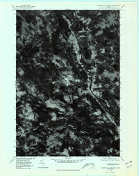
1978 Map of Brownville Junction
USGS Topo · Published 1981About this map
Brownville Junction sits as a primary corridor of development in this orthophotomap, where the river systems of the Maine woods dictate the pattern of human settlement. The imagery captures the dense forest canopy of the late 1970s, broken by the cleared lands around Barnard Corner and the distinct path of the West Branch Pleasant River as it winds southward. This aerial perspective emphasizes the stark contrast between the industrial and residential grid of the junction and the surrounding timberland. Water dominates the southern portion of the sheet, where the Sebec River flows from the eastern reaches of Sebec Lake. The map reveals the relationship between the natural waterways and the roads that navigate the varying elevations, providing a clear record of the landscape before significant modern changes in land use.
Find a feature on this map
7 named features on this map. Tap any name to fly to it.
Don’t see what you’re looking for? This feature index may not catch every label — zoom into the map to look around manually.
Map Details
Editions of this 1978 Brownville Junction Map
This is the sole edition of this map. No revisions or reprints were ever made.
Other maps of this area

1932 · Dover-Foxcroft
USGS Topo · 1:48,000

1933 · Boyd Lake
USGS Topo · 1:62,500

1935 · Dover-Foxcroft
USGS Topo · 1:62,500
1940 · Sebec
USGS Topo · 1:48,000
1943 · Sebec
USGS Topo · 1:62,500

1947 · Schoodic
USGS Topo · 1:62,500

1949 · Schoodic
USGS Topo · 1:62,500

1951 · Boyd Lake
USGS Topo · 1:50,000

1954 · Millinocket
USGS Topo · 1:250,000
1955 · Boyd Lake
USGS Topo · 1:62,500