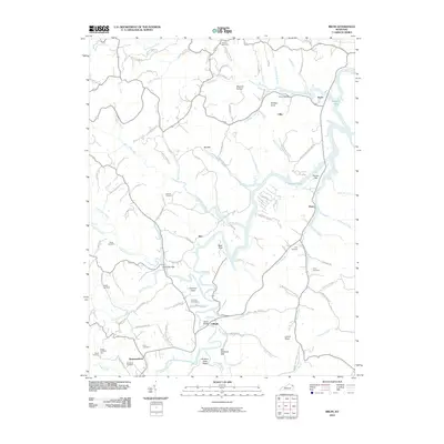
2010 Map of Bruin
USGS Topo · Published 2010About this map
Grayson Lake dominates the eastern landscape of this Elliott County quadrangle, where the Little Sandy River and its numerous tributaries like Big Gimlet Creek carve through the terrain. The map documents a rural landscape defined by family-named landmarks and small crossroads communities such as Ibex, Bruin, and Newfoundland. For genealogists and local historians, the sheet is exceptionally detailed, locating numerous family burial grounds including Lawson Cemetery, Kegley Cemetery, and Flannery Cemetery. The winding course of Bruin Creek and the presence of the Green Bridge near Cliffside illustrate the importance of water crossings and river-valley settlements in this part of Kentucky. Distinctive landforms like Kentucky Gap and Brokers Neck Ridge provide a clear picture of the area's physical geography as it stood in the early 21st century.
Find a feature on this map
98 named features on this map. Tap any name to fly to it.
Don’t see what you’re looking for? This feature index may not catch every label — zoom into the map to look around manually.
Map Details
Editions of this 2010 Bruin Map
This is the sole edition of this map. No revisions or reprints were ever made.
Other maps of this area

1903 · Kenova
USGS Topo · 1:125,000

1904 · Kenova
USGS Topo · 1:125,000

1950 · Bruin
USGS Topo · 1:24,000

1950 · Grahn
USGS Topo · 1:24,000

1950 · Isonville
USGS Topo · 1:24,000

1950 · Olive Hill
USGS Topo · 1:24,000

1950 · Ault
USGS Topo · 1:24,000

1950 · Sandy Hook
USGS Topo · 1:24,000

1953 · Grayson
USGS Topo · 1:24,000
1953 · Mazie
USGS Topo · 1:24,000