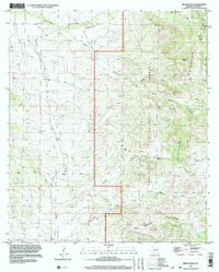
1996 Map of Bruno Peak
USGS Topo · Published 2003About this map
Chiricahua Mountains and Pedregosa Mountains meet in this landscape defined by deep drainages and cattle-ranching infrastructure as it appeared in the mid-1990s. The northern portion of the map is dominated by the Whitewater Draw, a prominent watercourse that cuts through a broad Mesa and provides a focal point for local survey lines. Moving east, the terrain ascends sharply into the Coronado National Forest, where Bruno Peak stands as a primary landmark above Bruno Saddle.
Find a feature on this map
23 named features on this map. Tap any name to fly to it.
Don’t see what you’re looking for? This feature index may not catch every label — zoom into the map to look around manually.
Map Details
Editions of this 1996 Bruno Peak Map
This is the sole edition of this map. No revisions or reprints were ever made.
Other maps of this area

1916 · Pearce
USGS Topo · 1:125,000

1917 · Chiricahua
USGS Topo · 1:125,000

1919 · Chiricahua
USGS Topo · 1:125,000

1922 · Swisshelm
USGS Topo · 1:62,500

1926 · Light
USGS Topo · 1:62,500

1926 · Rucker
USGS Topo · 1:62,500

1926 · Pedregosa
USGS Topo · 1:62,500

1955 · Douglas
USGS Topo · 1:250,000

1958 · Chiricahua Peak
USGS Topo · 1:62,500

1958 · Squaretop Hills
USGS Topo · 1:62,500