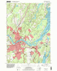
1996 Map of Brunswick
USGS Topo · Published 2001About this map
The Androscoggin River carves a deep bend around Brunswick and Topsham, defining a landscape where historic academic life meets mid-century military infrastructure. At the heart of the settlement, the campus of Bowdoin College and the landmark First Parish Cem represent the area's long-standing cultural roots, while the expansive Brunswick Naval Air Station dominates the eastern flatlands. The map reveals the intricate water network of Merrymeeting Bay, where the Cathance River and Muddy River converge amidst a series of large river islands like Cow Island and Driscoll Island. Local history is preserved in numerous family and community burial grounds, including Riverside Cem and Maquoit Cem, while the Maine Central RR tracks trace the industrial corridor connecting Cooks Corner to West Bath.
Find a feature on this map
71 named features on this map. Tap any name to fly to it.
Don’t see what you’re looking for? This feature index may not catch every label — zoom into the map to look around manually.
Map Details
Editions of this 1996 Brunswick Map
This is the sole edition of this map. No revisions or reprints were ever made.
Other maps of this area

1892 · Gardiner
USGS Topo · 1:62,500

1892 · Freeport
USGS Topo · 1:62,500

1894 · Bath
USGS Topo · 1:62,500

1908 · Lewiston
USGS Topo · 1:62,500

1920 · Bath
USGS Topo · 1:62,500

1941 · Freeport
USGS Topo · 1:62,500

1942 · Lewiston
USGS Topo · 1:62,500

1943 · Gardiner
USGS Topo · 1:62,500

1944 · Freeport
USGS Topo · 1:62,500

1945 · Bath
USGS Topo · 1:62,500