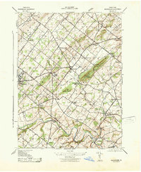
1943 Map of Buckingham
USGS Topo · Published 1943About this map
Buckingham Mountain stands as a prominent physical anchor in this region of Bucks County, shaping the local road and rail patterns of the early 1940s. The Reading railroad line cuts through the valley, serving small stops like Lahaska Sta and Bycot Sta that connected these agrarian communities to wider markets. The landscape is dotted with small-scale rural infrastructure, including numerous educational sites like the Hughesian School and Mozart School, alongside localized hubs such as Gardenville and Mechanicsville.
Find a feature on this map
53 named features on this map. Tap any name to fly to it.
Don’t see what you’re looking for? This feature index may not catch every label — zoom into the map to look around manually.
Map Details
Editions of this 1943 Buckingham Map
This is the sole edition of this map. No revisions or reprints were ever made.
Other maps of this area

1890 · Lambertville
USGS Topo · 1:62,500

1890 · Doylestown
USGS Topo · 1:62,500

1890 · Burlington
USGS Topo · 1:62,500

1891 · Lambertville
USGS Topo · 1:62,500

1891 · Doylestown
USGS Topo · 1:62,500

1893 · Germantown
USGS Topo · 1:62,500

1893 · Burlington
USGS Topo · 1:62,500

1894 · Lambertville
USGS Topo · 1:62,500

1894 · Germantown
USGS Topo · 1:62,500

1896 · Germantown
USGS Topo · 1:62,500
Featured Places
- Warrington Township, PA
- Buckingham Township, PA
- Solebury Township, PA
- Doylestown, PA
- Wrightstown Township, PA