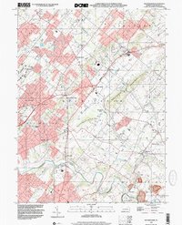
1999 Map of Buckingham
USGS Topo · Published 2001About this map
Buckingham Mountain and Little Buckingham Mtn rise above a landscape of established villages and shifting agricultural land in central Bucks County. This survey captured the area as residential expansion began to surround traditional hubs like Buckingham and Lahaska. The topography is defined by the winding course of Neshaminy Creek and its many tributaries, including Lahaska Creek and Watson Creek. Local infrastructure is well-documented, from the Central Bucks County Municipal Airport to the Bycot Sta rail point. Genealogists and local historians can locate several institutional landmarks, such as the Plumstead Cem, Mt Gilead Ch, and several community schools like Gardenville Sch and Buckingham Sch. The map preserves the transition from rural township life to modern suburban growth near the Doylestown border.
Find a feature on this map
58 named features on this map. Tap any name to fly to it.
Don’t see what you’re looking for? This feature index may not catch every label — zoom into the map to look around manually.
Map Details
Editions of this 1999 Buckingham Map
This is the sole edition of this map. No revisions or reprints were ever made.
Other maps of this area

1890 · Lambertville
USGS Topo · 1:62,500

1890 · Doylestown
USGS Topo · 1:62,500

1890 · Burlington
USGS Topo · 1:62,500

1891 · Lambertville
USGS Topo · 1:62,500

1891 · Doylestown
USGS Topo · 1:62,500

1893 · Germantown
USGS Topo · 1:62,500

1893 · Burlington
USGS Topo · 1:62,500

1894 · Lambertville
USGS Topo · 1:62,500

1894 · Germantown
USGS Topo · 1:62,500

1896 · Germantown
USGS Topo · 1:62,500
Featured Places
- Warrington Township, PA
- Buckingham Township, PA
- Solebury Township, PA
- Doylestown, PA
- Wrightstown Township, PA