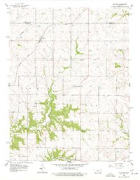
1956 Map of Bucyrus
USGS Topo · Published 1977About this map
Bucyrus and the surrounding farm country of the Kansas-Missouri border region are documented here in the mid-1950s. The landscape is a network of rural schoolhouses and small settlements defined by the paths of the Missouri Pacific and Missouri Kansas Texas railroads. A significant historical line, the South Boundary Shawnee Reserve, cuts across the center of the map, marking an earlier era of land division.
Find a feature on this map
18 named features on this map. Tap any name to fly to it.
Don’t see what you’re looking for? This feature index may not catch every label — zoom into the map to look around manually.
Map Details
Editions of this 1956 Bucyrus Map
2 editions found
Other maps of this area

1887 · Olathe
USGS Topo · 1:125,000

1893 · Olathe
USGS Topo · 1:125,000

1947 · Lawrence
USGS Topo · 1:250,000

1950 · Lawrence
USGS Topo · 1:250,000
1953 · Belton
USGS Topo · 1:24,000

1953 · Freeman
USGS Topo · 1:24,000

1953 · West Line
USGS Topo · 1:24,000

1956 · Stilwell
USGS Topo · 1:24,000

1956 · Bucyrus
USGS Topo · 1:24,000
1956 · Ocheltree
USGS Topo · 1:24,000