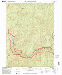
1998 Map of Bunker Creek
USGS Topo · Published 2001About this map
The Rogue National Wild and Scenic River dominates this portion of southwestern Oregon, carving a path through the junction of Josephine, Curry, and Douglas counties. This late-twentieth-century survey documents a landscape defined by its waterways and mining history, featuring the Benton Mine and Reno Mine near California Gulch. The river itself is a sequence of technical challenges, from the drop at Black Bar Falls to the churning Washboard Rapids and Slim Pickins Rapid. High-ground access is indicated by isolated outposts like Trappers Camp and Conley Camp, while the Horse Range divides the drainages of Bunker Creek and Whisky Creek. The presence of a Footbridge and Telephone Hole Riffle suggests the specific points of transit and communication that once served this remote section of the Rogue River corridor.
Find a feature on this map
57 named features on this map. Tap any name to fly to it.
Don’t see what you’re looking for? This feature index may not catch every label — zoom into the map to look around manually.
Map Details
Editions of this 1998 Bunker Creek Map
This is the sole edition of this map. No revisions or reprints were ever made.
Other maps of this area

1946 · Galice
USGS Topo · 1:62,500

1946 · Dutchman Butte
USGS Topo · 1:62,500

1948 · Galice
USGS Topo · 1:62,500

1948 · Dutchman Butte
USGS Topo · 1:62,500

1954 · Bone Mountain
USGS Topo · 1:62,500

1954 · Marial
USGS Topo · 1:62,500

1955 · Medford
USGS Topo · 1:250,000

1957 · Medford
USGS Topo · 1:250,000

1958 · Medford
USGS Topo · 1:250,000
1989 · Hobson Horn
USGS Topo · 1:24,000