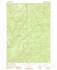
1989 Map of Hobson Horn
USGS Topo · Published 1989About this map
Siskiyou National Forest dominates this landscape along the boundary between Curry and Josephine Counties, where the drainage of the Indigo Creek system carves deep into the terrain. The map documents the intricate network of watercourses that define the region, including the North Fork and East Fork, as well as the prominent summit of Hobson Horn. Evidence of early back-country habitation is found at the Buck Camp (Site), located north of Buck Creek. The terrain is marked by significant elevations like Shasta Ridge, while water sources such as Montana Spring provide crucial landmarks in the dense woods. This provisional survey provides a clear view of the wilderness before later development, showing a land characterized by creeks like Silver Creek and Brandy Creek and narrow passages such as Browns Gulch.
Find a feature on this map
27 named features on this map. Tap any name to fly to it.
Don’t see what you’re looking for? This feature index may not catch every label — zoom into the map to look around manually.
Map Details
Editions of this 1989 Hobson Horn Map
This is the sole edition of this map. No revisions or reprints were ever made.
Other maps of this area

1917 · Kerby
USGS Topo · 1:125,000

1918 · Kerby
USGS Topo · 1:125,000

1945 · Kerby
USGS Topo · 1:125,000

1946 · Galice
USGS Topo · 1:62,500

1948 · Galice
USGS Topo · 1:62,500

1954 · Marial
USGS Topo · 1:62,500

1954 · Selma
USGS Topo · 1:62,500

1954 · Pearsoll Peak
USGS Topo · 1:62,500

1955 · Medford
USGS Topo · 1:250,000

1957 · Medford
USGS Topo · 1:250,000