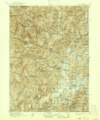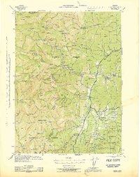
1945 Map of Kerby
USGS Topo · Published 1945About this map
Eureka Mine and the Queen of Bronze Mine anchor a landscape defined by the mineral wealth and early timber interests of southwestern Oregon. This 1940s survey reveals a dense network of mining operations and remote ranching outposts throughout the Siskiyou National Forest, long before modern developments altered the character of the Illinois River valley. The presence of several guard stations, including the Ferren Guard Station and Store Gulch Guard Station, reflects the era's intensive forestry management.
Find a feature on this map
186 named features on this map. Tap any name to fly to it.
Don’t see what you’re looking for? This feature index may not catch every label — zoom into the map to look around manually.
Map Details
Editions of this 1945 Kerby Map
This is the sole edition of this map. No revisions or reprints were ever made.
Historical Maps of Cave Junction Through Time
3 maps found