Loading...
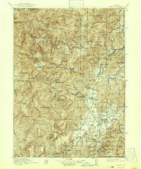
Loading map...1917 Map of Kerby
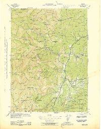
USGS Topo · Published 1942About this map
The Illinois River and its numerous tributaries, including Silver Creek, Briggs Creek, and Sucker Creek, define the landscape of this southern Oregon territory during the early twentieth century. Settlement patterns follow the river valleys and mountain passes, with established communities at Kerby, Waldo, and O'Brien serving as hubs for the surrounding wilderness. The map reveals an intensive history of resource extraction, noting several prominent operations such as the Queen of Bronze Mine, Waldo Mine, and the Eureka Mine.
Find a feature on this map
151 named features on this map. Tap any name to fly to it.
Don’t see what you’re looking for? This feature index may not catch every label — zoom into the map to look around manually.
Map Details
Date Portrayed1917
Date Published1942
PublisherU.S. Geological Survey
Map TypeTopographic
Scale1:125,000
Physical Dimensions16.5 x 19.8 inches
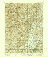
Editions of this 1917 Kerby Map
3 editions found

Historical Maps of Cave Junction Through Time
3 maps found

Featured Locations
Source Details
SourceU.S. Geological Survey
CopyrightPublic Domain