Loading...
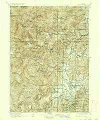
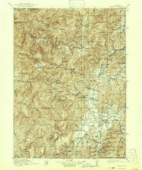
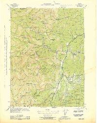
Loading map...1917 Map of Kerby
USGS Topo · Published 1937About this map
Waldo and Takilma stand as the primary hubs in the southern reach of this survey, reflecting the early 20th-century mining economy of southwestern Oregon. This area of the Siskiyou National Forest is defined by a dense network of mineral extraction sites, including the Queen of Bronze Mine, Cowboy Mine, and Eureka Mine. The Illinois River and its numerous tributaries, such as Rough and Ready Creek, carve through the terrain, providing the water necessary for the hydraulic operations common during this period.
Find a feature on this map
113 named features on this map. Tap any name to fly to it.
Don’t see what you’re looking for? This feature index may not catch every label — zoom into the map to look around manually.
Map Details
Date Portrayed1917
Date Published1937
PublisherU.S. Geological Survey
Map TypeTopographic
Scale1:125,000
Physical Dimensions16.6 x 19.8 inches
Editions of this 1917 Kerby Map
3 editions found

Historical Maps of Cave Junction Through Time
3 maps found

Featured Locations
Source Details
SourceU.S. Geological Survey
CopyrightPublic Domain