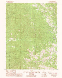
1991 Map of Burbeck
USGS Topo · Published 1991About this map
The Noyo River and Burbeck River carve through this Mendocino County landscape, where the settlements of Shake City and Burbeck sit along the narrow watercourses. This 1991 provisional map captures a remote section of the California Coast Ranges characterized by deep gulches and high ridges, including Three Chop Ridge and Soda Basin. To the south, a portion of the Jackson State Forest covers the terrain, with James Creek Road providing limited access through the timberlands. Smaller outposts like Crowley, Summit, and Broaddus are situated near the headwaters of numerous creeks, such as Mill Creek and Willits Creek. The map reflects a landscape defined by its rugged hydrology, where named features like Twin Rocks and Seven Gulch serve as critical landmarks for navigating the dense, forested interior far from the main coastal thoroughfares.
Find a feature on this map
29 named features on this map. Tap any name to fly to it.
Don’t see what you’re looking for? This feature index may not catch every label — zoom into the map to look around manually.
Map Details
Editions of this 1991 Burbeck Map
This is the sole edition of this map. No revisions or reprints were ever made.
Other maps of this area

1920 · Glenblair
USGS Topo · 1:62,500

1921 · Branscomb
USGS Topo · 1:62,500

1922 · Willits
USGS Topo · 1:62,500

1942 · Willits
USGS Topo · 1:62,500

1943 · Glenblair
USGS Topo · 1:62,500

1944 · Willits
USGS Topo · 1:62,500

1951 · Branscomb
USGS Topo · 1:62,500

1951 · Laytonville
USGS Topo · 1:62,500

1957 · Ukiah
USGS Topo · 1:250,000

1960 · Ukiah
USGS Topo · 1:250,000