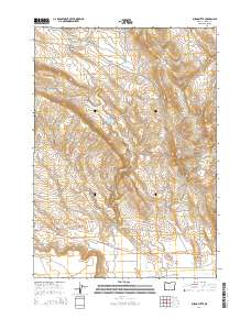
2014 Map of Burns Butte
USGS Topo · Published 2014About this map
Burns Butte rises as a prominent landmark in this high-desert landscape of Harney County, characterized by a complex network of seasonal water management and logging access. The map reveals an arid terrain punctuated by essential water sources such as Wheeler Spring, Alder Spring, and Rimrock Spring. Ranching and resource management are evident through numerous catchments like Erenos Reservoir, Halfway Reservoir, and the W Willow Cr Reservoir. This 2014 survey documents a working landscape where geography and industry intersect. Broad, low-lying areas like Willow Creek Flats and Sandy Flat contrast with the carved-out relief of Fenwick Canyon and Brush Canyon. The presence of the Hines Logging Rd and Burns-Izee Rd underscores the historical and ongoing importance of timber transport and regional connectivity through the Sage Hen Valley.
Find a feature on this map
33 named features on this map. Tap any name to fly to it.
Don’t see what you’re looking for? This feature index may not catch every label — zoom into the map to look around manually.
Map Details
Editions of this 2014 Burns Butte Map
This is the sole edition of this map. No revisions or reprints were ever made.
Other maps of this area

1955 · Burns
USGS Topo · 1:250,000

1958 · Burns
USGS Topo · 1:250,000

1959 · Burns
USGS Topo · 1:250,000

1959 · Dog Mountain
USGS Topo · 1:62,500

1960 · Burns
USGS Topo · 1:62,500

1960 · Burns
USGS Topo · 1:24,000

1975 · Burns
USGS Topo · 1:24,000

1980 · Palomino Buttes
USGS Topo · 1:24,000

1981 · Sage Hen Hill
USGS Topo · 1:24,000
1981 · Holmes Canyon
USGS Topo · 1:24,000