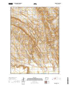
2020 Map of Burns Butte
USGS Topo · Published 2020About this map
Willow Creek Flats and the high desert terrain of Harney County define this landscape, anchored by the prominent rise of Burns Butte in the northeast. The area is characterized by an intricate network of drainages and seasonal water sources, including Willow Cr and Sage Hen Cr, which are supplemented by various catchment points like West Willow Cr Reservoir and Erenos Reservoir. These water features, alongside springs such as Rimrock Spring and Wheeler Spring, illustrate the essential infrastructure of life in this arid region.
Find a feature on this map
33 named features on this map. Tap any name to fly to it.
Don’t see what you’re looking for? This feature index may not catch every label — zoom into the map to look around manually.
Map Details
Editions of this 2020 Burns Butte Map
This is the sole edition of this map. No revisions or reprints were ever made.
Other maps of this area

1955 · Burns
USGS Topo · 1:250,000

1958 · Burns
USGS Topo · 1:250,000

1959 · Burns
USGS Topo · 1:250,000

1959 · Dog Mountain
USGS Topo · 1:62,500

1960 · Burns
USGS Topo · 1:62,500

1960 · Burns
USGS Topo · 1:24,000

1975 · Burns
USGS Topo · 1:24,000

1980 · Palomino Buttes
USGS Topo · 1:24,000

1981 · Sage Hen Hill
USGS Topo · 1:24,000
1981 · Holmes Canyon
USGS Topo · 1:24,000