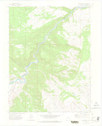
1972 Map of Burns South
USGS Topo · Published 1975About this map
The Colorado River winds through a landscape defined by steep canyons and high mesas in this early 1970s survey. The Denver and Rio Grande Western railroad tracks hug the riverbank, passing through Derby Junction as the line navigates the narrow valley floor. To the west, the protected lands of the White River National Forest dominate the high ground, while to the east, Greenhorn Mountain and its surrounding gulches create a complex system of drainages. Evidence of land use is scattered throughout the terrain, from the Range Well and Drill Hole locations to the small settlement at Burns and the isolated Jack Flats. A network of Jeep Trails and Pack Trails provides the primary access to the interior, reflecting the area's transition between working ranchland and recreational forest.
Find a feature on this map
29 named features on this map. Tap any name to fly to it.
Don’t see what you’re looking for? This feature index may not catch every label — zoom into the map to look around manually.
Map Details
Editions of this 1972 Burns South Map
4 editions found
Other maps of this area

1927 · Glenwood Springs
USGS Topo · 1:125,000

1930 · Glenwood Springs
USGS Topo · 1:125,000

1957 · Leadville
USGS Topo · 1:250,000

1959 · Leadville
USGS Topo · 1:250,000

1960 · Leadville
USGS Topo · 1:250,000

1962 · Leadville
USGS Topo · 1:250,000

1962 · Gypsum
USGS Topo · 1:24,000

1962 · Eagle
USGS Topo · 1:24,000

1964 · Leadville
USGS Topo · 1:250,000

1972 · Blue Hill
USGS Topo · 1:24,000