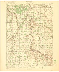
1921 Map of Burt
USGS Topo · Published 1921About this map
The Flint River meanders through the heart of this agricultural landscape at the convergence of Saginaw, Genesee, and Shiawassee counties. In the early 1920s, this region was defined by a dense network of one-room schoolhouses serving a rural population, including the Pine Grove School and McGregor School. The village of Flushing stands as a primary hub in the south, while the northern sections are anchored by Taymouth and the map's namesake, Burt.
Find a feature on this map
89 named features on this map. Tap any name to fly to it.
Don’t see what you’re looking for? This feature index may not catch every label — zoom into the map to look around manually.
Map Details
Editions of this 1921 Burt Map
2 editions found
Other maps of this area

1917 · Chesaning
USGS Topo · 1:62,500

1917 · St. Charles
USGS Topo · 1:62,500

1919 · Saginaw
USGS Topo · 1:62,500

1919 · Burt
USGS Topo · 1:62,500

1920 · Flint
USGS Topo · 1:62,500

1920 · Holly
USGS Topo · 1:62,500

1921 · Burt
USGS Topo · 1:62,500

1922 · Holly
USGS Topo · 1:62,500

1922 · Durand
USGS Topo · 1:62,500

1922 · Flint
USGS Topo · 1:62,500