1943 Map of Burt
USGS Topo · Published 1943About this map
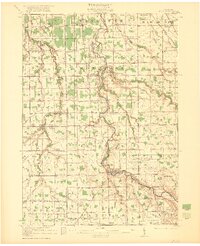
The Flint River carves a winding path through the borderlands of Saginaw and Genesee counties during the early 1940s, providing a focal point for the developing towns of Flushing and Montrose. This landscape is defined by its rural density, evidenced by the high concentration of named country schools such as McIntyre Sch, Dyball Sch, and the uniquely situated County Line Sch. These small educational outposts, often located at two-mile intervals, suggest a well-established farm economy where local communities remained tightly centered around their schoolhouses and churches, including St Michaels Ch in the west.
Find a feature on this map
74 named features on this map. Tap any name to fly to it.
Don’t see what you’re looking for? This feature index may not catch every label — zoom into the map to look around manually.
Map Details
Editions of this 1943 Burt Map
This is the sole edition of this map. No revisions or reprints were ever made.