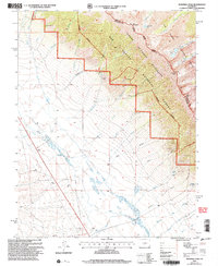
2001 Map of Bushnell Peak
USGS Topo · Published 2005About this map
Villa Grove sits as the primary settlement on this western edge of the San Luis Valley, serving as a gateway to the high elevations of the Sangre De Cristo Wilderness. The landscape transitions sharply from the alluvial flats near San Luis Creek and Rock Creek into the towering heights of the Rio Grande National Forest. For those researching local family history, the Villa Grove Cem is a prominent landmark located just south of the town center.
Find a feature on this map
42 named features on this map. Tap any name to fly to it.
Don’t see what you’re looking for? This feature index may not catch every label — zoom into the map to look around manually.
Map Details
Editions of this 2001 Bushnell Peak Map
This is the sole edition of this map. No revisions or reprints were ever made.
Other maps of this area

1950 · Valley View Hot Springs
USGS Topo · 1:24,000

1954 · Pueblo
USGS Topo · 1:250,000

1956 · Montrose
USGS Topo · 1:250,000

1957 · Pueblo
USGS Topo · 1:250,000

1958 · Pueblo
USGS Topo · 1:250,000

1959 · Montrose
USGS Topo · 1:250,000

1959 · Bonanza
USGS Topo · 1:62,500

1959 · Howard
USGS Topo · 1:62,500

1960 · Montrose
USGS Topo · 1:250,000

1962 · Pueblo
USGS Topo · 1:250,000