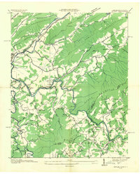
1935 Map of Butler
USGS Topo · Published 1935About this map
The Butler settlement and the winding Watauga River dominate this 1935 Tennessee Valley Authority advance sheet, recorded just before the landscape was fundamentally altered. This survey captures a mountain economy defined by the Southern Railway and the timber industry, evidenced by the Whiting Lumber Company Branch. The social fabric of the valley is deeply detailed, showing a network of community landmarks such as Watauga Academy, Sugar Grove Ch, and local schoolhouses like Bradley Sch and Frog Pond Sch. From the high elevations of Stone Mountain and Beech Mountain to the riverbanks at Elk Mills, the map provides a precise look at the original locations of family homes and cemeteries, including Dugger Cem, before the creation of Watauga Lake submerged much of this historic valley floor.
Find a feature on this map
80 named features on this map. Tap any name to fly to it.
Don’t see what you’re looking for? This feature index may not catch every label — zoom into the map to look around manually.
Map Details
Editions of this 1935 Butler Map
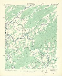
2 editions found
Other maps of this area

1891 · Roan Mountain
USGS Topo · 1:125,000

1893 · Cranberry
USGS Topo · 1:125,000

1894 · Roan Mountain
USGS Topo · 1:125,000

1895 · Cranberry
USGS Topo · 1:125,000

1899 · Cranberry
USGS Topo · 1:125,000

1902 · Cranberry
USGS Topo · 1:125,000

1904 · Roan Mountain
USGS Topo · 1:125,000

1934 · Valle Crucis
USGS Topo · 1:24,000

1934 · White Rocks Mtn
USGS Topo · 1:24,000

1934 · Elk Park
USGS Topo · 1:24,000