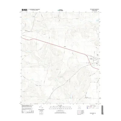
2014 Map of Butler West
USGS Topo · Published 2014About this map
Butler and its western surroundings are defined by a network of creeks and small settlements in this 2014 geographic study. The western outskirts of the town are marked by the Butler Municipal Airport and the community of Goldson, while the rural landscape to the west features the hamlets of Mizell and Howard. The terrain is deeply etched by a complex drainage system including Patsiliga Cr in the north and the extensive reach of Little Whitewater Cr, which flows through the central and southern portions of the quadrangle. For those researching local family history, the Lieutenant Colonel Brewer Cem provides a specific point of interest in the southeastern corner near Rustins Pond. This documentation of Taylor County shows how the rural road network, including names like Grace Mill Rd and Watson Pond Rd, continues to follow the land's natural contours and water bodies like McCants Millpond.
Find a feature on this map
61 named features on this map. Tap any name to fly to it.
Don’t see what you’re looking for? This feature index may not catch every label — zoom into the map to look around manually.
Map Details
Editions of this 2014 Butler West Map
This is the sole edition of this map. No revisions or reprints were ever made.
Other maps of this area

1955 · Phenix City
USGS Topo · 1:250,000

1957 · Phenix City
USGS Topo · 1:250,000

1958 · Phenix City
USGS Topo · 1:250,000

1971 · Rupert
USGS Topo · 1:24,000

1971 · Prattsburg
USGS Topo · 1:24,000
1971 · Baldwinville
USGS Topo · 1:24,000

1971 · Fickling Mill
USGS Topo · 1:24,000

1971 · Ideal North
USGS Topo · 1:24,000
1971 · Butler West
USGS Topo · 1:24,000
1971 · Butler East
USGS Topo · 1:24,000