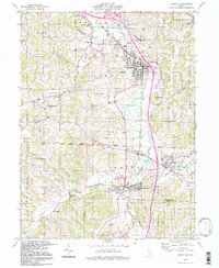
1994 Map of Byesville
USGS Topo · Published 1998About this map
The industrial and agricultural landscape of Guernsey County is defined here by the extensive Strip Mines that surround the village of Byesville. This 1990s record of the terrain shows a region deeply tied to extraction, with many open pits and Kilns scattered across Jackson and Cambridge townships. Along Wills Creek and the Seneca Fork, older patterns of settlement remain visible, from the established village centers of Buffalo and Pleasant City to smaller locales like Lucasburg and Robins.
Find a feature on this map
49 named features on this map. Tap any name to fly to it.
Don’t see what you’re looking for? This feature index may not catch every label — zoom into the map to look around manually.
Map Details
Editions of this 1994 Byesville Map
This is the sole edition of this map. No revisions or reprints were ever made.
Other maps of this area

1909 · Antrim
USGS Topo · 1:48,000

1909 · Summerfield
USGS Topo · 1:62,500

1909 · Cambridge
USGS Topo · 1:62,500

1911 · Antrim
USGS Topo · 1:62,500

1911 · Cumberland
USGS Topo · 1:62,500

1911 · Summerfield
USGS Topo · 1:62,500

1912 · Cambridge
USGS Topo · 1:62,500

1949 · Clarksburg
USGS Topo · 1:250,000

1951 · Canton
USGS Topo · 1:250,000

1953 · Canton
USGS Topo · 1:250,000