1937 Map of Cache
USGS Topo · Published 1937About this map
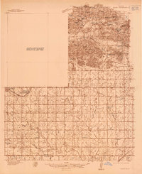
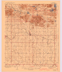
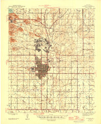
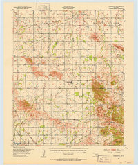
Wichita Mountains Wildlife Refuge dominates the northern landscape of this survey, where the rugged granite peaks of Mt Scott, Mt Sheridan, and Mt Roosevelt rise above the surrounding prairie. This 1930s snapshot by U.S. Geological Survey engineers shows a transitional era for the region, documenting the proposed site for Lake Thomas and the established resort character of Medicine Park. South of the mountains, the rural character of Comanche County is meticulously detailed with a dense network of one-room schoolhouses and country churches. Local history is preserved through the locations of Post Oak Sch, Pecan Sch, and Deyo Memorial Chapel, alongside rail sidings like Taupa Switch and Gardner Switch on the St Louis and San Francisco line, marking the era's agricultural transportation hubs.
Find a feature on this map
48 named features on this map. Tap any name to fly to it.
Don’t see what you’re looking for? This feature index may not catch every label — zoom into the map to look around manually.
Map Details
Editions of this 1937 Cache Map
This is the sole edition of this map. No revisions or reprints were ever made.
Other maps of this area

1937 · Quanah Mountain
USGS Topo · 1:24,000
1942 · Cache
USGS Topo · 1:62,500
1946 · Lawton
USGS Topo · 1:62,500

1949 · Mount Scott
USGS Topo · 1:24,000
1949 · Cooperton
USGS Topo · 1:62,500

1949 · Quanah Mountain
USGS Topo · 1:24,000

1949 · Fort Sill
USGS Topo · 1:24,000

1950 · Snyder
USGS Topo · 1:62,500

1950 · Saddle Mountain
USGS Topo · 1:62,500

1955 · Lawton
USGS Topo · 1:250,000