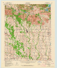
1956 Map of Cache
USGS Topo · Published 1965About this map
The Wichita Mountains Wildlife Refuge dominates this mid-century landscape, characterized by the dramatic relief of Mount Scott, Mount Roosevelt, and Elk Mountain. The map illustrates a complex transition from these rocky peaks to the agrarian plains of Comanche County and Tillman County. Human settlement is centered on the town of Cache and the village of Indiahoma, both linked by the St Louis San Francisco railroad line.
Find a feature on this map
61 named features on this map. Tap any name to fly to it.
Don’t see what you’re looking for? This feature index may not catch every label — zoom into the map to look around manually.
Map Details
Editions of this 1956 Cache Map
3 editions found
Other maps of this area

1937 · Cache
USGS Topo · 1:48,000

1937 · Quanah Mountain
USGS Topo · 1:24,000

1942 · Cache
USGS Topo · 1:62,500

1946 · Lawton
USGS Topo · 1:62,500

1949 · Mount Scott
USGS Topo · 1:24,000

1949 · Cooperton
USGS Topo · 1:62,500

1949 · Quanah Mountain
USGS Topo · 1:24,000

1949 · Fort Sill
USGS Topo · 1:24,000

1950 · Snyder
USGS Topo · 1:62,500

1950 · Saddle Mountain
USGS Topo · 1:62,500