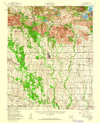
1956 Map of Cache
USGS Topo · Published 1960About this map
The Wichita Mountains Wildlife Refuge and the Fort Sill Military Reservation dominate the northern landscape of this mid-century survey, where the rocky peaks of the Wichita Mountains meet the plains of southwest Oklahoma. The map documents a complex network of upland water bodies, including Quanah Parker Lake, French Lake, and Osage Lake, while the southern half transitions into more open agricultural land. Local social hubs are clearly marked, such as the Nazarene Indian Mission near Indiahoma and the Deyo Memorial Chapel and Deyo Cemetery further east. The presence of these institutional and spiritual centers, alongside the St Louis San Francisco railroad line passing through Cache, illustrates the established rural community structure that persisted alongside the expanding federal and military land holdings in the mid-1950s.
Find a feature on this map
50 named features on this map. Tap any name to fly to it.
Don’t see what you’re looking for? This feature index may not catch every label — zoom into the map to look around manually.
Map Details
Editions of this 1956 Cache Map
3 editions found
Other maps of this area

1937 · Cache
USGS Topo · 1:48,000

1937 · Quanah Mountain
USGS Topo · 1:24,000

1942 · Cache
USGS Topo · 1:62,500

1946 · Lawton
USGS Topo · 1:62,500

1949 · Mount Scott
USGS Topo · 1:24,000

1949 · Cooperton
USGS Topo · 1:62,500

1949 · Quanah Mountain
USGS Topo · 1:24,000

1949 · Fort Sill
USGS Topo · 1:24,000

1950 · Snyder
USGS Topo · 1:62,500

1950 · Saddle Mountain
USGS Topo · 1:62,500