
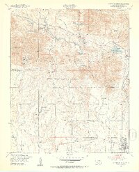
1949 Map of Quanah Mountain
USGS Topo · Published 1953About this map
Wichita Mountains Wildlife Refuge dominates this terrain, showcasing a high concentration of named summits and water bodies during the late 1940s. The landscape is defined by granite peaks like Elk Mountain and Mt Marcy, intersected by dramatic features such as The Narrows and Wild Horse Canyon. Cultural landmarks are centered around the heritage of the region, notably the Old Star House and the Post Oak Mission south of the refuge boundary. The map captures the intersection of conservation and military utility, as the eastern edge borders the Fort Sill Mil Res. Recreation and local administration are evident at Quanah Parker Lake, Craterville Park, and the Refuge Headquarters. From the Rock Crusher to the Landing Strip near Spanish Canyon, the map reveals the varied infrastructure supporting the refuge and the nearby community of Cache at a time when the St Louis rail line still influenced the local geography.
Find a feature on this map
62 named features on this map. Tap any name to fly to it.
Don’t see what you’re looking for? This feature index may not catch every label — zoom into the map to look around manually.
Map Details
Editions of this 1949 Quanah Mountain Map
2 editions found
Other maps of this area

1937 · Cache
USGS Topo · 1:48,000

1937 · Quanah Mountain
USGS Topo · 1:24,000

1942 · Cache
USGS Topo · 1:62,500

1949 · Mount Scott
USGS Topo · 1:24,000

1949 · Cooperton
USGS Topo · 1:62,500

1950 · Snyder
USGS Topo · 1:62,500

1950 · Saddle Mountain
USGS Topo · 1:62,500

1955 · Lawton
USGS Topo · 1:250,000

1956 · Post Oak Creek
USGS Topo · 1:24,000

1956 · Saddle Mountain
USGS Topo · 1:24,000