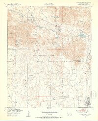
1949 Map of Quanah Mountain
USGS Topo · Published 1953About this map
The Wichita Mountains Wildlife Refuge Boundary defines the northern half of this landscape, where high peaks like Elk Mountain and Quanah Mountain overlook a complex network of reservoirs and canyons. Established land use patterns are visible in the contrast between the protected wilderness and the Fort Sill Mil Res to the southeast. Local history is anchored by the Post Oak Mission and the Old Star House, reflecting the area's significance to the Comanche people and early settlement.
Find a feature on this map
70 named features on this map. Tap any name to fly to it.
Don’t see what you’re looking for? This feature index may not catch every label — zoom into the map to look around manually.
Map Details
Editions of this 1949 Quanah Mountain Map
2 editions found
Other maps of this area

1937 · Cache
USGS Topo · 1:48,000

1937 · Quanah Mountain
USGS Topo · 1:24,000

1942 · Cache
USGS Topo · 1:62,500

1949 · Mount Scott
USGS Topo · 1:24,000

1949 · Cooperton
USGS Topo · 1:62,500

1949 · Quanah Mountain
USGS Topo · 1:24,000

1950 · Snyder
USGS Topo · 1:62,500

1950 · Saddle Mountain
USGS Topo · 1:62,500

1955 · Lawton
USGS Topo · 1:250,000

1956 · Post Oak Creek
USGS Topo · 1:24,000