
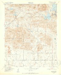
1949 Map of Mount Scott
USGS Topo · Published 1952About this map
The Wichita Mountains Wildlife Refuge dominates the northern landscape of this post-war survey, where the rugged topography transitions into the Fort Sill Military Reservation. This era of development is marked by significant water management and recreation sites, including Medicine Park situated near the Lawton Dam and the expansive Lake Lawtonka. A unique cultural landmark, the site of the Easter Pageant, is noted near Mt Roosevelt, illustrating the area's role as a regional gathering place.
Find a feature on this map
58 named features on this map. Tap any name to fly to it.
Don’t see what you’re looking for? This feature index may not catch every label — zoom into the map to look around manually.
Map Details
Editions of this 1949 Mount Scott Map
2 editions found
Other maps of this area

1937 · Cache
USGS Topo · 1:48,000

1937 · Quanah Mountain
USGS Topo · 1:24,000

1942 · Cache
USGS Topo · 1:62,500

1946 · Lawton
USGS Topo · 1:62,500

1949 · Quanah Mountain
USGS Topo · 1:24,000

1949 · Fort Sill
USGS Topo · 1:24,000

1950 · Saddle Mountain
USGS Topo · 1:62,500

1955 · Lawton
USGS Topo · 1:250,000

1956 · Post Oak Creek
USGS Topo · 1:24,000

1956 · Saddle Mountain
USGS Topo · 1:24,000